Volcanoes in Java and Bali are never only background scenery. They rise above rice fields, temple routes, cities, and coastal roads as reminders that Indonesian landscapes are shaped by both deep geological time and daily human attention. Their slopes can provide fertile soil and water, but they can also release ash, lahars, lava, and pyroclastic flows. Communities living near them therefore inherit a double awareness: the mountain gives, and the mountain can endanger.
A museum approach to this subject must hold together landform, memory, and sacred geography. Objects from Java or Bali may appear in a gallery as sculpture, textile, ritual vessel, architectural fragment, or photograph, but many of them refer to a wider landscape of mountains, springs, temples, ancestral places, and remembered disasters. To interpret them well, museums need to show how volcanoes help people organize space, time, obligation, and historical experience.
Mountains as Living Landmarks
In Java, volcanoes often dominate the horizon so completely that they become points of orientation for both movement and imagination. Mount Merapi, north of Yogyakarta, is among the best-known examples. It is a highly active stratovolcano, but it is also a presence in regional memory, settlement history, and everyday geography. People do not encounter it only when it erupts. They see it from roads, fields, neighborhoods, and ritual routes.
This continuing visibility matters. A mountain that appears every day can become a stable sign even when its geological behavior is unstable. It helps define direction, belonging, and locality. Stories about past eruptions, evacuations, ashfall, and recovery attach themselves to slopes and river valleys. The volcano becomes a landmark of memory as much as a landmark of stone.
Sacred Geography and Built Form in Java
Central Java's sacred architecture shows how mountains could be interpreted through religious and political imagination. Borobudur, located in a valley of Central Java, is not a volcano, but its stepped form and monumental setting make it essential to any museum discussion of sacred landscape. UNESCO describes the temple as combining ideas of a terraced mountain with Buddhist cosmology, a reminder that architecture can transform landscape principles into stone.
This does not mean every monument copies a volcano in a simple literal way. The more careful point is that mountains, elevation, ascent, and cosmic order were powerful ideas within the region's visual and religious vocabulary. Terraces, axes, processional movement, and views toward surrounding landforms helped structure religious experience. In such settings, geography was not neutral space around a monument. It was part of how meaning was made.
Merapi, Hazard, and Remembered Time
Merapi also teaches that sacred geography cannot be separated from risk. Smithsonian records describe a long pattern of activity including dome growth, avalanches, pyroclastic flows, ashfall, and lahars. These processes have affected communities repeatedly, sometimes with severe loss. A museum that presents Merapi only as a symbol of grandeur would miss the lived knowledge required to remain near an active volcano.
Memory around Merapi is therefore practical as well as spiritual or historical. It includes evacuation routes, river channels, warning systems, destroyed houses, rebuilt neighborhoods, and stories told by older residents. Such memory is not frozen in the past. It changes after each eruption and each period of alert. The mountain becomes a teacher of time, showing that heritage includes preparedness, adaptation, and the difficult work of returning.
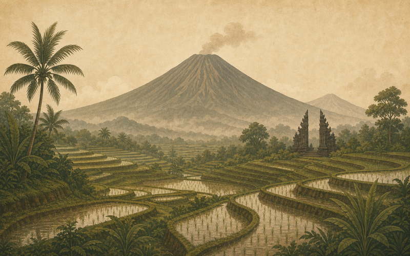
Bali's Volcanic Spine
Bali's sacred geography is also strongly shaped by volcanoes, especially Agung and Batur. Mount Agung is Bali's highest volcano and has long been associated with powerful religious significance on the island. Batur, set within a large caldera complex with Lake Batur, gives another example of how volcanic form, water, and settlement come together. The landscape is not only dramatic; it is organized by relationships between upland sources and lowland life.
The Smithsonian Global Volcanism Program identifies Batur as a caldera volcano and Agung as a stratovolcano, reminding museum visitors that Bali's sacred mountains are also active geological systems. This dual identity matters. A shrine, water temple, terrace, or pilgrimage route may be embedded in a landscape whose form was made by eruption, collapse, lava, ash, and erosion. Cultural meaning is built within geological inheritance.
Water, Agriculture, and Ritual Order
Volcanic landscapes are not defined only by fire. In Bali, water flowing from uplands is central to agriculture and ritual organization. UNESCO's recognition of the Cultural Landscape of Bali Province emphasizes the subak system, water temples, rice terraces, and the philosophy of Tri Hita Karana, which links the realms of spirit, human society, and nature. This framework helps explain why sacred geography cannot be reduced to isolated temples.
Water temples and irrigation networks show how mountain landscapes become social systems. Water must be distributed, timed, blessed, negotiated, and maintained. Rice terraces below volcanic slopes depend on ecological conditions, but they also depend on cooperative institutions and ritual calendars. Museums can use this example to show visitors that environment and religion are not separate topics in Balinese heritage. They are braided through the practical work of farming.
Objects, Offerings, and Landscape Memory
Many museum objects from Java and Bali carry traces of volcanic geography even when no mountain appears on their surface. A carved figure, a temple photograph, a ritual textile, or a vessel used near a shrine may belong to practices shaped by direction, altitude, water source, temple hierarchy, or ancestral memory. Without this context, an object can look self-contained when it actually points outward toward a larger terrain.
Offerings are especially important here. They are temporary, but they mark relationships between people, places, and unseen powers. In a volcanic landscape, acts of offering may acknowledge protection, gratitude, danger, or continuity. Museums should be cautious about making broad claims for every community, yet they can still explain that ritual acts often help people inhabit landscapes that are both sustaining and unpredictable.
Interpreting Volcanoes in the Museum
To interpret volcanoes well, museums need more than maps and eruption dates. Geological timelines are essential, but they should be placed beside oral history, ritual practice, agriculture, architecture, and contemporary hazard knowledge. A gallery might show how ash creates fertile soils, how lahars follow river channels, how temples relate to mountains, and how communities remember earlier crises. The result is a fuller account of place.
This approach also prevents romantic simplification. Volcanoes should not be presented as mystical scenery detached from real communities, nor only as disasters detached from culture. They are part of inhabited worlds. Their meaning is made through fear, reverence, labor, planning, artistic form, and repeated acts of remembrance. Museum interpretation is strongest when it allows all of these dimensions to remain visible.
Conclusion
Volcanoes in Java and Bali shape more than the physical surface of the islands. They organize horizons, nourish fields, threaten settlements, anchor sacred stories, and give form to architecture, water systems, and ritual life. Their power lies partly in this combination. They are geological forces that become cultural reference points through long human attention.
For museums, the lesson is to interpret volcanic landscapes as relationships rather than scenery. When objects are connected back to mountains, water, memory, danger, and devotion, visitors can better understand why volcanoes remain central to the cultural geography of Java and Bali.